The Jet Stream
This year on October 2nd, New Orleans set a new record for the highest recorded temperature it’s ever had in the month of October: 96 degrees Fahrenheit. The previous record was 67 years ago, with 92 degrees in 1952. This record setting first week of October comes right after the hottest and driest September, with dryness documents going back to 1946. Records for the hottest and driest Septembers have not just been exclusive to New Orleans however, as Baton Rouge, McComb, and Gulfport reached temperatures that have not been seen by as far back as 1892.
As the National Weather Service joked on Twitter, New Orleans is in “Augtober.”
“We’re running about 10 degrees above normal,” said Phil Grigsby, a meteorologist at the Slidell office of the National Weather Service.
Despite these historical heat waves, New Orleans and other places in America have experienced more severe winter weather, and New Orleans has even gotten a little snow in recent years. To understand these seemingly contradictory events, we must understand how global warming effects the jet streams.
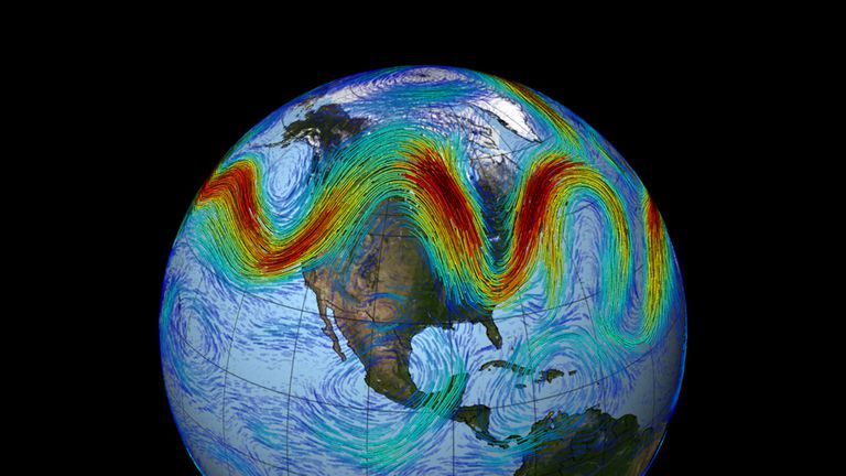
The jet streams are fast-moving, meandering currents of air that circulate the poles, the two major ones being the polar-front and subtropical jet streams. They form when hot and cold air meet, and so are stronger during winter because it’s when the air temperature and pressure differences that fuel them tend to be most pronounced. The polar-front stream also marks the boundary between arctic air from the north and warm, tropical air from the south.
The earth’s polar regions warm more quickly than anywhere else due to global warming. As they get warmer, the less temperature contrast there is, which produces slower, weaker streams.
“When the jet stream enters this wavy state, extreme weather tends to occur on either side of the amplified ridges and troughs as the storm track becomes locked in place. Then, specific regions experience long periods of cool and stormy or, contrarily, hot and dry weather” said Daniel Swain, a climate scientist at UCLA and the National Center for Atmospheric Research.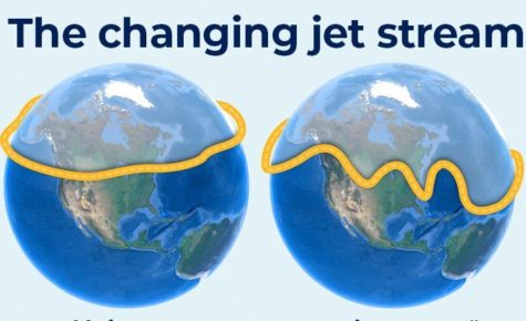
The jet streams surround the polar vortices, which are large areas of cold, low pressure air at the north and south poles. As weaker jet streams fluctuate or break, they move massive amounts of air around and make the polar vortex unstable. This leads to the polar vortex expanding and sending cold Arctic air into the jet stream, leading to frigid winter weather and storms southward, in the case of the polar-front stream. This unstable condition is what ultimately causes such drastic changes in temperature. Due to climate change however, these cold snaps have been getting warmer on average as well. New Orleans’ last real snowfall was nine months before Hurricane Katrina in 2004, and the record snowfall for the city was recorded December 30th, 1963, with 5 inches of snow. While it seems unlikely that we will receive that amount of snowfall, with the unpredictable nature of the jet streams, it’s possible we may get a dusting.