
Hurricane Ida
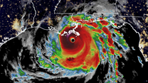
Striking New Orleans on a Saturday, Hurricane Ida proved devastating for much of coastal Louisiana. Within a time span of 24 hours, Ida quickly developed from a Category 1 hurricane to a Category 4 hurricane, most likely due to the temperature of the water in the Gulf of Mexico. In September, the water in the Gulf is much warmer because of the heat, allowing for storms such as Ida to grow much stronger in shorter periods of time. After hitting the coast, Hurricane Ida remained a Category 4 hurricane for about 4 hours, with winds around 150 mph (240 km/h), before it slowed down and turned into a Category 3 hurricane. Much of coastal Louisiana and cities such as Houma are still in ruin, many with blue roofs and broken fences.
One of the main reasons Hurricane Ida strengthened so quickly was due to what is known as the “brown ocean effect”. The brown ocean effect normally occurs when a large storm soaks a dry, hot area of land. This causes the heat trapped in the ground to release into the atmosphere, making the storm much stronger. In Ida’s case, the wetlands were extremely dry due to the hot summer, and as a result, Ida was allowed to feed off of the heat in the atmosphere.
Coincidentally, August 29th – the day Hurricane Ida made landfall – was the 15th anniversary of the landfall of Hurricane Katrina. This caused several families to think of the worst when it came to storm intensity.